What is an Adjusted Census Urban Boundary?
Following each decennial U.S. Census, federal rules allow the Michigan Department of Transportation (MDOT), in cooperation with partners, the option to adjust the United States Census Urban Area (CUA) boundaries.
The Adjusted Census Urban Boundary (ACUB) is an area that determines the official urban designation for a road. The ACUB is subject to Federal Highway Administration (FHWA) approval. Once approved, it is used to declare a road “urban” within the federal Highway Performance Monitoring System (HPMS) and State of Michigan Act 51 urban county road designation. Roads within or on the ACUB border are considered urban. Roads completely outside the boundary are rural.
ACUBs are important to transportation agencies for the following reasons:
- ACUBs may be used to determine eligibility for certain Title 23 funding categories (e.g., Surface Transportation Program).
- ACUBs may have a greater density of federal-aid roads compared to rural as described by using the National Functional Classification system.
- For county transportation agencies, the location of this boundary affects funding distributions from the Michigan Transportation Fund.
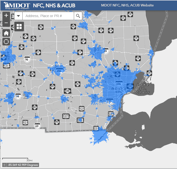
2020 Census Urban Areas
The Michigan Department of Transportation’s National Functional Classification (NFC), National Highway System (NHS), and Adjusted Census Urban Boundary (ACUB) Web Map.
2020 ACUB Adjustment “Smoothing” Process
U.S. Census UA boundaries can be very irregular. Irregular boundaries may cause roads to switch between rural and urban status many times along their length. Adjusting or ‘smoothing’ the boundaries creates more consistent urban/rural road segment classifications.
The process of adjusting the Census Urban Areas is a cooperative and voluntary process where local transportation agencies will be invited by MDOT to collectively review and adjust the Census Urban Areas (UA) outward in workshops held throughout the state.
Until the proposed 2020 ACUB boundaries are approved by the Federal Highway Administration (FHWA) and entered within the MDOT databases in 2025, the 2010 ACUBs will continue to be in effect. The U.S. Census urban areas are only used as a base for the ACUB.
The new ACUB must include all the UA. Where modifications are proposed to the 2010 ACUB, it is important to identify which changes have occurred in the area since the last census. Additional questions to ask include:
- Do changes justify an increase in urban area?
- Can ACUB areas be identified that no longer smooth the area or do not act as urban?
Areas can be removed or added to the 2010 ACUB to create the new proposed ACUB. Agencies in attendance are encouraged to provide input. After local agency input is provided, if disagreements arise, the boundary decision is up to the MDOT ACUB coordinator. If necessary, FHWA may be called in to act as an arbitrator as a last resort.
Ideally, proposed ACUBs can be identified in the field from data shown on maps. They should follow jurisdictional and geographical features.
Frequently Asked Questions
How does ACUB impact Act 51 allocations?
The ACUB area could affect the Act 51 county urban funding distribution. Changing the ACUB boundary does not increase or decrease Act 51 funding, but may affect the percentages distributed among county road commission for Act 51 urban funding.
How does ACUB impact other funding allocations?
Adjusting the ACUBs does not affect the Census Urban Area (CUA) population numbers, allocations, or the federal metropolitan planning (PL) funding levels that are available to local agencies or any federal funds available via the SEMCOG federal-aid committees.
Ways to get Involved
The ‘Introduction to the Adjusted Census Urban Boundary (ACUB)’ virtual workshop on July 20 will prepare you for an in-person workshop to make adjustments to the 2020 Census Urban Boundary at the SEMCOG office on August 2, 2023. Please join us to review the process used to create the new Adjusted Census Urban Boundaries (ACUBs) in the region.
ACUB Adjustment Workshops (in-person)
Following the virtual workshop, please join SEMCOG and the Michigan Department of Transportation (MDOT) for an in-person meeting at SEMCOG’s office on August 2 at 9:30 am. This meeting is for transportation stakeholders, including county road commissions, cities, villages, and transit operators, to review and make changes to the region’s Adjusted Census Urban Boundary (ACUB) for the five counties of:
- Livingston
- Macomb
- Monroe
- Oakland
- Wayne
Review focus area ACUB maps for these five counties:
- City of Detroit Map 1,
- City of Detroit Map 2,
- City of Detroit Map 3
- City of Detroit Map 4
- Dundee Map
- Holly map
- Monroe map
- Richmond map
- Toledo map.
The counties of Washtenaw and St. Clair are hosting their own in-person ACUB review meetings.
Washtenaw Area Transportation Study (WATS)
Date: August 3, 2023
Time: 1:30 pm to 4:00 pm
Focus Area: Washtenaw County
Location: 200 N. Main Street
Ann Arbor, Michigan, 48104
Review focus area ACUB maps:
- Ann Arbor Map 1
- Ann Arbor Map 2
- Chelsea Map
- Dexter Map
- Milan Map.
For meeting information, contact Anton Schauerte.
St. Clair County Office of Transportation Planning Commission
Date: August 9, 2023
Focus Area: St. Clair County
Location: 200 Grand River Street, Suite 202
Port Huron, Michigan 48060
Time: 10:30 am to 12:30 pm
Review focus area ACUB maps: Port Huron’s map and Richmond’s map.
For meeting information, contact Lindsay Wallace.


Leave a Reply