Earlier this summer, a SEMCOG University on “Practical Asset Management Planning” featured experts from the City of Detroit, Macomb County Department of Roads, and Michigan Department of Transportation (MDOT) to discuss the development of transportation asset management plans.
According to Michigan PA 325 of 2018, asset management is an “ongoing process of maintaining, preserving, upgrading, and operating physical assets cost -effectively, based on a continuous physical inventory and condition assessment and investment to achieve established performance goals.” The development of an asset management plan outlines the community’s commitment to using an asset management process to maintain roads, bridges, and other infrastructure.
SEMCOG webinar, Practical Asset Management Planning
Where Have We Been and Where are We Going
Roger Belknap, Transportation Asset Management Council (TAMC) Coordinator, MDOT, described the history of transportation asset management plans in the state. Under Public Act 338 of 2006, cities and villages were granted flexibility in managing major and minor street funds if they have an approved asset management plan. Thus far, 59 cities and villages have taken advantage of the plan requirement and submitted plans for review.
Public Act 325 of 2018 formalized what should be included in a road or bridge asset management plan, required the state develop a standard template for plans, and established a requirement that the largest road owners (those with 100 or more miles under their jurisdiction) submit asset management plans on a regular basis.
TAMC recognizes that the plans are an evolving process. Future guidance includes reassessing the culverts and traffic signals sections of these compliance plans. They are also looking for ways to refine policies and procedures to make the plans more useful to communities, TAMC, and the public.

Macomb County’s Transportation Asset Management Plan – Realigning Priorities
Scott Wanagat, County Highway Engineer from the Macomb County Department of Roads, shared how developing an asset management plan helped realign priorities. Macomb County is using this opportunity to move staff and resources in a common direction. They aim to prioritize investments to keep roads and bridges in good or fair conditions from slipping into poor condition.
The county is moving away from a “worst-first” orientation to a system-wide focus on performance. The plan is to look at the road and bridge network systematically, using a data-driven approach to monitor the performance of the transportation system. The county is backing up this commitment to improving the road network health by doubling their capital preventive maintenance budget over the next few years.
Macomb County’s Mix of Fixes Target
Plan to Action, Turning Policy into Projects
Sam Krassenstein, Deputy Director of Mobility Innovation for the City of Detroit, presented how the city is reprioritizing road projects. Prior to 2018, the city lacked a coordinated process for selecting projects. Many projects were developed using a 1-year capital planning horizon, with limited input from other road and utility partners.
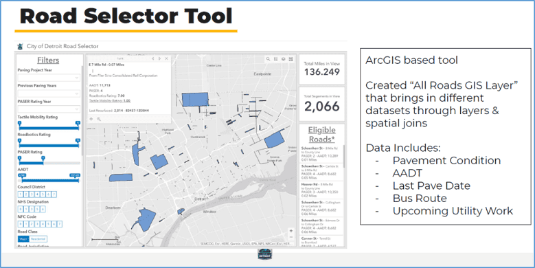
The city is implementing a data-driven process to monitor road projects and extend the planning horizon beyond a single year. Recognizing the need to provide a framework to improve the process, the city is leveraging available resources such as PASER road condition data and their GIS capabilities to support decision-making. A GIS-based road selector tool integrates various datasets and filters to determine candidate road projects.
Road Selector Tool

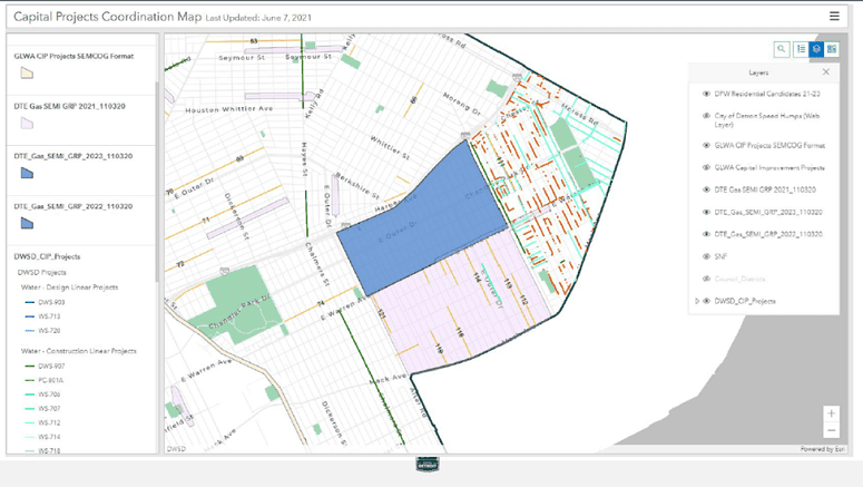
Detroit also notes the importance of communicating with public and private utility operators. The city wanted to minimize utility cuts in roads that were recently repaved and thusly created a process for coordination with Detroit Water and Sewerage Department, Great Lakes Water Authority, and DTE Energy. These partnerships help to ensure that all utilities can be fixed for a road in a coordinated fashion.
Detroit’s Utility Coordination Website
SEMCOG Resources
SEMCOG has resources to help communities develop their own asset management programs.
There are several things that we can do to help you start or expand asset management plans, including:
- Assistance with PASER data collection,
- Annual local Road Data Collection grants,
- Regional infrastructure coordination, and
- Additional web-based data tools.
SEMCOG has provided assistance to local communities with PASER data collection. The region participates in the annual collection of PASER road condition data on federal aid roads. The agency will give direct assistance to communities to gain familiarity with the PASER data collection process, loan laptop and GPS equipment, and provide assistance for using Roadsoft.
SEMCOG is committed to helping communities collect PASER road condition data on local roads. The agency has committed $50,000 per year in targeted and first-come-first-served grants. SEMCOG will be sending out a call for projects shortly for FY2022, which will support data collection between October 2021 and September 2022.
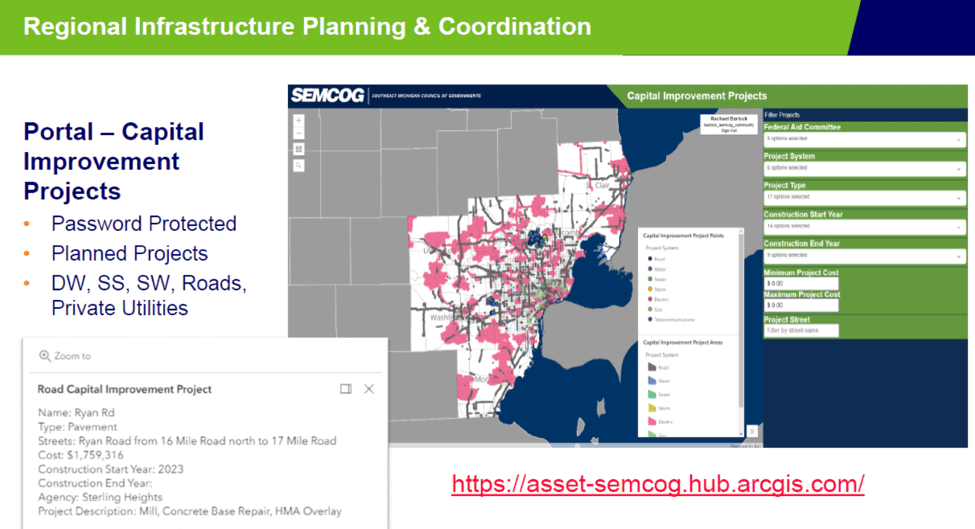
SEMCOG recently unveiled a Capital Improvement Projects coordination portal. The password-protected web portal allows public and private utilities, communities, and water and sewer providers to enter planned projects onto a map. The data will be viewable only by organizations that have securely shared their own data. The goal of the portal is to help utilities, communities, and regional planners make better decisions when planning work within the right-of-way. When a road project is planned, utilities, water and sewer providers, and others can make their improvements at the same time. No one wants to finish a road project only to have a utility come along a few years later to tear the road up again. Coordination will make life easier and less expensive for communities, utility providers, and the public.
Capital Improvement Coordination Portal
SEMCOG has multiple web tools available to help develop asset management plans. The Pavement Condition map shows road conditions on major roads by lane miles, centerline miles, and can be filtered to show data most interesting to your community.


Leave a Reply